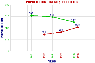
Plockton (Am Ploc) Classification and Statistics Settlement Type: village Population (1991): 360 (1971): 288 (1961): 254 (1881): 440 (1871): 516 (1861): 539 Tourist Rating: N/A Text of Entry Updated: 19-JUL-2022 Location Latitude: 57.3407°N Longitude: 5.6509°W National Grid Reference: NG 804 337 A range of modern and historical maps are accessible through the map tab on the right of this page Get directions by entering the UK postcode of your location, home or hotel here eg. EH1 3YT Use the tabs on the right of this page to see other parts of this entry Related Entries There are 34 related entries. (0 Attractions, 1 Council Area, 1 Historical County, 20 Features, 1 Parish, 4 People and 7 Settlements) Names that are not linked do not currently contain any information. Council Area: Highland Features: Achaidh na h-Inich, Loch Balmacara Estate, The Beinn Raimh Carron, Loch Coire na Ba Duirinish Railway Station Duncraig Castle Duncraig Railway Station Glasaich, Eilean Kishorn Island Lochalsh Lundie, Loch Mor, Rubha National Centre of Excellence in Traditional Music Plockton Aerodrome Plockton High School Plockton Railway Station Ravens' Craig Tower Skye and Lochalsh Strome Islands Historical Counties: Ross and Cromarty Parishes: Lochalsh People: Ian Begg Sorley MacLean(Somhairle MacGill-Eain) Sir Alexander Matheson(Sir Alexander Matheson of Lochalsh) Thomas Telford Settlements: Achintraid Ardaneaskan Badicaul Drumbuie Duirinish Kyle of Lochalsh Stromeferry
There are 34 related entries. (0 Attractions, 1 Council Area, 1 Historical County, 20 Features, 1 Parish, 4 People and 7 Settlements)
Names that are not linked do not currently contain any information.
By using our site you agree to accept cookies, which help us serve you better