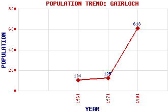
Gairloch Classification and Statistics Settlement Type: village Population (1991): 613 (1971): 125 (1961): 104 Tourist Rating: Text of Entry Updated: 08-JUN-2019 Location Latitude: 57.7284°N Longitude: 5.6929°W National Grid Reference: NG 802 769 A range of modern and historical maps are accessible through the map tab on the right of this page Get directions by entering the UK postcode of your location, home or hotel here eg. EH1 3YT Use the tabs on the right of this page to see other parts of this entry Related Entries There are 43 related entries. (4 Attractions, 1 Council Area, 1 Historical County, 2 Families, 9 Features, 9 Parishes, 4 People and 13 Settlements) Names that are not linked do not currently contain any information. Attractions: Gairloch Heritage Museum Inverewe Garden Inverness Town House North Coast 500 Council Area: Highland Families: MacKenzie MacLeod Features: Cloiche, Loch na Gairloch Golf Club Gairloch High School Gairloch, Loch Kerry Falls Power Station Kinkell Castle Melvaig Peninsula Shieldaig, Loch Tollie, Loch Historical Counties: Ross and Cromarty Parishes: Applecross Gairloch Gairloch Kilmuir Lochalsh Lochbroom Lochcarron Portree Stornoway People: John Baillie William (Willie) Fernie Osgood Mackenzie Queen Victoria Settlements: Auchtercairn Carn Dearg Charlestown Lonemore Melvaig Mial Opinan Port Henderson Shieldaig Smithstown South Erradale Strath Talladale
There are 43 related entries. (4 Attractions, 1 Council Area, 1 Historical County, 2 Families, 9 Features, 9 Parishes, 4 People and 13 Settlements)
Names that are not linked do not currently contain any information.
By using our site you agree to accept cookies, which help us serve you better